
Colorado River Structural Deficit
The Colorado River is overallocated. The seven basin states, Mexico, and tribal nations together hold legal entitlements to more water than the river reliably delivers. That gap — between what the Law of the River has promised water users and what the river can provide — is the structural deficit, and it is the central legal and operational fact of Colorado River management today.
The structural deficit is not a product of recent drought, though drought has made it impossible to ignore. Negotiators and legislators built it into the river’s legal framework at its foundation and compounded it with every subsequent allocation; an infrastructure system large enough to absorb the shortfall obscured the problem for decades — until it wasn’t.
What is the Structural Deficit?
The arithmetic is straightforward. The 1922 Colorado River Compact obligates the Upper Basin to deliver 75 million acre-feet to the Lower Basin at Lee Ferry over each successive ten-year period — an obligation that averages 7.5 million acre-feet annually but does not impose a strict annual delivery floor. The 1944 United States-Mexico Water Treaty added a commitment of 1.5 million acre-feet annually to Mexico. Combined with the Lower Basin’s own 7.5 million acre-feet allocation, total allocated demand against the river reaches 16.5 million acre-feet per year on an annualized basis. The Upper Basin’s ten-year delivery obligation effectively functions as a perpetual accounting exercise against a river that does not always cooperate.
The Colorado River does not reliably deliver what water users have been promised. It never has.
Tree ring reconstructions and long-term streamflow records indicate that the river's natural flow at Lee Ferry — the measuring point that divides the Upper and Lower Basins — averages approximately 14.8 million acre-feet annually over the past five centuries. In the twentieth and twenty-first centuries, consumptive use, reservoir evaporation, and system losses reduce available water further still. From 2000 through the present, average annual flows have run closer to 12 million acre-feet — well below both the long-term average and the allocated demand.
The gap between 16.5 million acre-feet of allocation and 12 to 14.8 million acre-feet of reliable supply is the structural deficit. It is not a rounding error. It is a systemic overcommitment that has shaped every water crisis in the basin and will define every negotiation over the river's future.
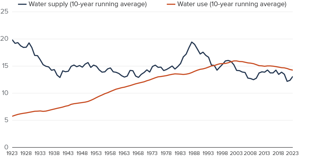
Water supply and use in the Colorado River Basin, 1923–2023 (10-year running averages). Despite significant demand management efforts since 2000, use continues to exceed available supply. Source: Public Policy Institute of California, adapted from USBR Colorado River Basin Water Supply and Demand Study (2012) with updated USBR historical data. Supply estimates for 2021–23 are provisional.
How was the Deficit Built?
The structural deficit was not an accident — it was a foreseeable consequence of decisions made under political pressure, with incomplete data, during an anomalously wet period in the river's recorded history.
The negotiators of the 1922 Colorado River Compact based their allocation on streamflow records covering approximately twenty years — a period that happened to coincide with one of the wettest intervals in the river's multi-century hydrological record. Those records suggested an average annual flow of 17 to 18 million acre-feet at Lee Ferry. Dividing 15 million acre-feet between the two basins appeared to leave a comfortable surplus. It did not.
The problem was not simply that the negotiators used a short and unrepresentative data record. It was that the political dynamics of the negotiation made a generous allocation inevitable. Each basin state needed enough water to support its anticipated future development. No state would sign a compact that constrained its growth below what it believed the river could support. The result was an allocation that reflected political necessity rather than hydrological reality.
Subsequent allocations compounded the problem. The Upper Basin Compact of 1948 apportioned the Upper Basin's 7.5 million acre-feet among Colorado, Utah, Wyoming, and New Mexico on a percentage basis — allocations premised on the same overstated flow estimates as the 1922 Compact. The 1944 Treaty added Mexico’s 1.5 million acre-feet on top of the domestic allocations without reducing the basin states’ entitlements. The Colorado River Basin Project Act of 1968 authorized the Central Arizona Project on the assumption that Arizona's full 2.8 million acre-foot entitlement was available to develop.
Each subsequent layer of the Law of the River rested on the foundation of the 1922 Compact’s arithmetic — arithmetic that overstated the river's reliable yield by several million acre-feet per year. By the time the infrastructure was in place to deliver on those allocations, the basin’s water users had been promised far more water than the river could reliably provide.
The Mexico Obligation
The 1944 United States-Mexico Water Treaty commits the United States to deliver 1.5 million acre-feet annually to Mexico at the international boundary. That obligation is fixed. It does not flex with drought conditions, reservoir levels, or interstate political impasses. It is a binding international treaty obligation that sits inside every calculation about how much water is actually available to domestic users.
The Treaty does provide for proportionate reductions in Mexico's delivery during "extraordinary drought" or when domestic supplies are insufficient to meet United States obligations — but the threshold for invoking those provisions is high, and the diplomatic consequences of reducing Mexico's allocation are significant. As a practical matter, the 1.5 million acre-feet commitment functions as a senior obligation that must be satisfied before domestic shortage allocations are calculated.
Mexico's entitlement also raises water quality obligations. Decades of upstream agricultural drainage and consumptive use concentrated salinity in the river’s lower reaches until the water Mexico received damaged crops and violated the Treaty’s implied quality standards. Minute 242 (1973) of the International Boundary and Water Commission (IBWC) and the Colorado River Basin Salinity Control Act of 1974 addressed the most acute salinity problems, but water quality remains a live issue in the US-Mexico water relationship.
For domestic water managers calculating available supply, the Mexico obligation means the effective ceiling on domestic allocation is not 16.5 million acre-feet but 15 million — and that 15 million must be delivered from a river that averages 12 to 14.8 million acre-feet of natural flow, after accounting for evaporation, system losses, and the effects of a warming and drying regional climate.
The Reservoir System and Its Limitations
The Bureau of Reclamation built the Colorado River’s major storage reservoirs — Lake Powell behind Glen Canyon Dam and Lake Mead behind Hoover Dam — to manage the river's natural variability. In wet years, the system stores excess flows. In dry years, operators release stored water to meet downstream obligations. Reclamation designed the system to buffer the gap between variable natural supply and consistent allocated demand.
For several decades, that buffer worked. The reservoirs filled during wet cycles, accumulated carry-over storage, and absorbed the structural deficit without exposing it through delivery shortfalls. The gap between allocation and reliable supply was real, but accumulated storage from years of above-average inflows masked it.
The drought has exhausted that buffer. Beginning in 2000, a prolonged drought — intensified by rising temperatures that increase evaporation and reduce snowpack — steadily drew down both reservoirs. Lake Powell reached its lowest level since initial filling in 2022, approaching the minimum power pool elevation at which Glen Canyon Dam can no longer generate hydropower. Lake Mead fell to levels not seen since Reclamation first filled the reservoir in the 1930s, prompting the Bureau of Reclamation to issue its first-ever federal shortage declarations on the Colorado River in 2021.
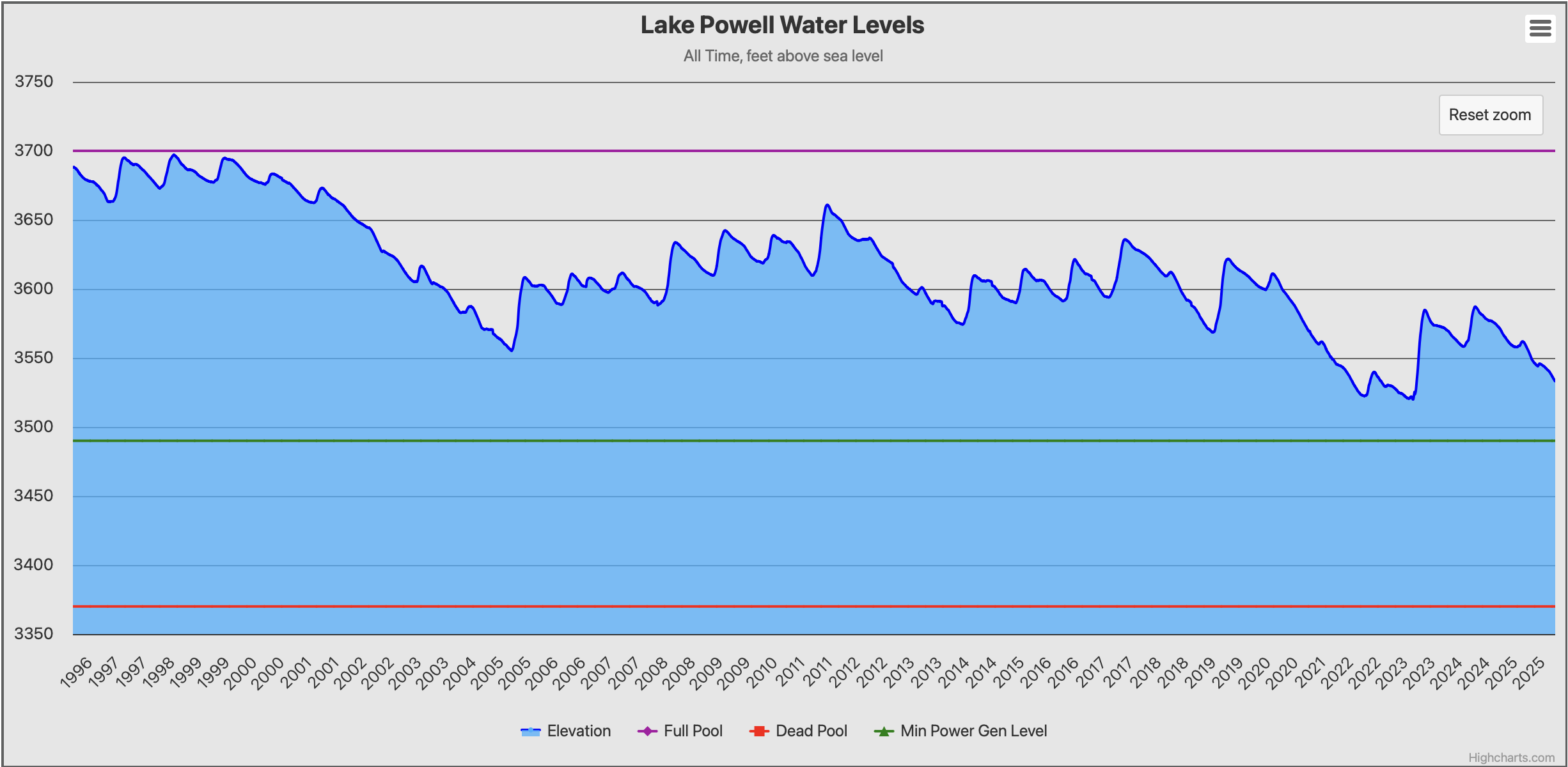
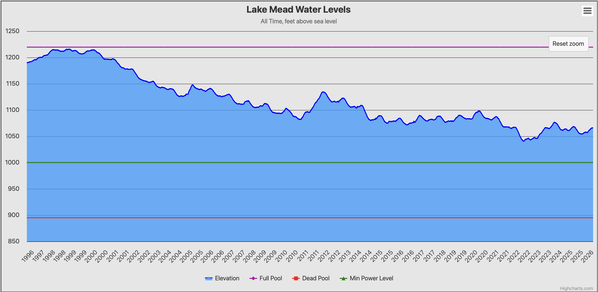
Lake Powell and Lake Mead daily water surface elevation, 1996-present. Reference lines indicate Full Pool, Minimum Power Generation level, and Dead Pool. Source: water-data.com (graphs.water-data.com), data courtesy U.S. Bureau of Reclamation. Underlying USBR elevation data is in the public domain.
The reservoir drawdown revealed what the storage system had concealed: the structural deficit is not a projected future problem; it is a present operational reality. The river is delivering less water than the system requires, and operators have drawn the storage buffer down to levels that cannot sustain continued overdraft.
Reclamation publishes monthly 24-Month Studies projecting reservoir elevations under multiple hydrology scenarios. Those projections are the operational window into where the system stands at any given moment and how much buffer remains. They are among the most closely watched documents in Western water management.
Who Bears the Risk?
The structural deficit does not fall equally on all water users. The prior appropriation priority system determines who bears shortage exposure — and the answer depends heavily on the priority date of each user's entitlement.
In the Lower Basin, the Bureau of Reclamation administers shortage through a tiered system the 2007 Interim Guidelines established and the 2019 Drought Contingency Plans modified. Lake Mead’s elevation triggers shortage tiers, requiring progressively deeper cuts to junior entitlements as the reservoir falls. Arizona bears the greatest exposure among the Lower Basin states — its Central Arizona Project entitlement carries a junior priority position — the political price Congress extracted for the 1968 authorization — placing CAP contractors among the first to face curtailment under shortage conditions.
Nevada and California hold more senior entitlements and face smaller proportional cuts under the current shortage framework, though California's structural reliance on Colorado River water — particularly through the Metropolitan Water District and the Imperial Irrigation District — means that even modest delivery reductions carry significant consequences.
The Upper Basin's exposure is different in character. Upper Basin states do not operate under the same tiered shortage framework as the Lower Basin. Their obligation is to deliver 7.5 million acre-feet to the Lower Basin at Lee Ferry over each ten-year period — a compact obligation rather than a shortage tier. If Upper Basin consumptive use threatens compliance with that delivery obligation, all Upper Basin uses are potentially at risk regardless of their individual state priority dates.
Tribal nations occupy a legally anomalous position in the shortage framework. Their reserved water rights are senior to virtually every non-tribal entitlement in the basin — but many of those rights remain unquantified, and the 2007 Guidelines and 2019 DCPs structured the shortage tiers around state allocations without formally accounting for tribal reserved rights. How far shortage curtailment protects tribal entitlements, and whether operators must satisfy unquantified tribal rights before applying shortage tiers, rank among the most consequential unresolved legal questions in the basin.

Shortage tiers, delivery reductions, and conservation contributions under the 2007 Interim Guidelines, Minute 323, Lower Basin Drought Contingency Plan, and Binational Water Scarcity Contingency Plan, by Lake Mead elevation (figures in thousand acre-feet). California bears no mandatory shortage obligation under the 2007 Interim Guidelines; Arizona absorbs the largest share at every tier. These tiers govern operations through 2026 and will be superseded by post-2026 operational guidelines currently under federal rulemaking. Source: U.S. Bureau of Reclamation / U.S. Department of the Interior (public domain).
Where Things Stand Now
The 2007 Interim Guidelines, the 2019 Drought Contingency Plans, and IBWC Minute 323 governing US-Mexico cooperative conservation all expire at the end of 2026. The post-2026 operational framework — whatever form it takes — will mark the first time managers must operate the Colorado River under a legal structure that formally acknowledges the structural deficit rather than managing around it.
The seven basin states have twice missed federal deadlines to reach a consensus replacement framework. The Bureau of Reclamation has committed to finalizing operational guidelines by October 2026, with or without state agreement. The competing proposals the Upper and Lower Basin states submitted reflect fundamentally different views about how to distribute shortage burdens — disagreements that trace directly back to the priority system, the Compact's basin division, and the unresolved status of tribal reserved rights.
What is not in dispute is the underlying arithmetic. The river cannot deliver what water users have been promised. Every negotiation over post-2026 operations is ultimately a negotiation over who absorbs the difference — and the legal framework the basin has built over the past century will determine the answer, beginning with the over-allocated arithmetic of the 1922 Compact.
The Bureau of Reclamation publishes the Annual Lower Colorado River Water Accounting Report documenting actual water use, deliveries, and accounting against entitlements for the Lower Basin states and tribes. That report provides the authoritative annual record of how the structural deficit plays out in operational terms and stands as an essential reference for anyone working on Colorado River water matters.