
The Arizona Groundwater Crisis: Paper Water, Dry Wells, and the Colorado River Collision
Arizona built an economic empire in the desert by writing laws that allowed it to pump ancient fossil groundwater, and then writing a second set of laws that promised to eventually stop. The state is now colliding with the physical limits of both.
The modern State of Arizona exists because of two massive hydraulic interventions. The first was the aggressive mining of Pleistocene-era groundwater — water that fell as rain and snow during the last ice age and has been slowly accumulating in deep desert aquifers ever since — to fuel early agricultural and urban expansion. The second was the Central Arizona Project (CAP), a 336-mile engineering marvel completed in 1993 that lifts Colorado River water over mountain ranges and across desert basins to deliver it to Phoenix, Tucson, and the agricultural districts of Pinal County.
For decades, the CAP allowed Arizona to mask its groundwater deficit. Surface water arrived cheap and plentiful, and the state developed an elaborate legal architecture — storage credits, replenishment districts, and paper accounting systems — that transformed excess Colorado River water into the legal justification for explosive suburban growth. Developers built subdivisions on top of depleted aquifers, pointed to paper credits generated by water stored somewhere else in the basin, and received state certificates declaring their water supply legally secure for 100 years.
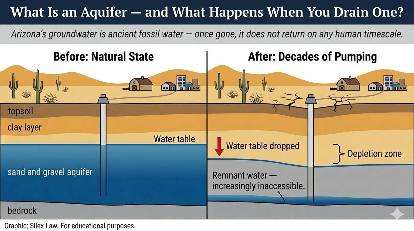
What happens underground when an aquifer is drained. Sediment grains that were once held apart by water pressure compact permanently as water tables decline — a process that cannot be reversed by future recharge. Source: U.S. Geological Survey. Graphic: Silex Law. For educational purposes.
That architecture is failing. The Colorado River is in a structural deficit driven by a century of over-allocation and accelerating aridification. Under the priority system governing the river, Arizona's CAP allocation bears the first and deepest cuts as the river shrinks. As surface water disappears, Arizona's cities, farms, and industries are being forced back onto aquifers that decades of legal accounting obscured but could not replenish. The crisis facing Arizona is not simply that it is running out of water. It is that its legal framework actively conceals the physical reality of depletion — until the wells go dry.
Why This Crisis Affects You
The Arizona groundwater crisis is routinely framed as a future environmental problem or an abstract accounting dispute between water lawyers and regulators. It is neither. It is a present-day infrastructure and economic crisis whose costs land on homeowners, ratepayers, and taxpayers whether they understand the law or not.
When an aquifer is drawn down faster than it can recharge, the geologic pore spaces that held the water collapse. The ground physically sinks — a process called land subsidence. In parts of Pinal and Maricopa counties, the land has already subsided by more than fifteen feet in some areas. This differential settling is not merely unsightly. It tears apart the infrastructure built on top of it. It cracks building foundations, shears well casings, ruptures municipal water mains, and changes the gradient of gravity-fed irrigation canals and sewer systems that were engineered for level ground. In the most extreme cases, it produces earth fissures — massive cracks in the desert floor, miles long and dozens of feet deep, that swallow roads and redirect floodwaters. Taxpayers and utility ratepayers absorb the cost of repairing and replacing that infrastructure, whether or not they live near the subsidence.
The economic exposure runs deeper than infrastructure. Arizona's growth engine depends on its ability to project certainty to investors. The Phoenix metropolitan area has positioned itself as a global hub for advanced semiconductor manufacturing, securing multi-billion dollar commitments from companies requiring massive, uninterruptible water supplies. The state's residential real estate market, which drives a significant portion of its tax base, depends on the credibility of the 100-year water supply guarantees that state law requires developers to obtain before breaking ground. If those guarantees are exposed as hydrologically hollow — as the state's own data increasingly suggests they are — the economic consequences will not wait for the physical water to run out. Capital moves faster than aquifers drain.
The water policy decisions that shape Arizona's aquifers are made not by hydrologists but by developers, municipal water providers, and state legislators. The financial consequences of those decisions fall on everyone.
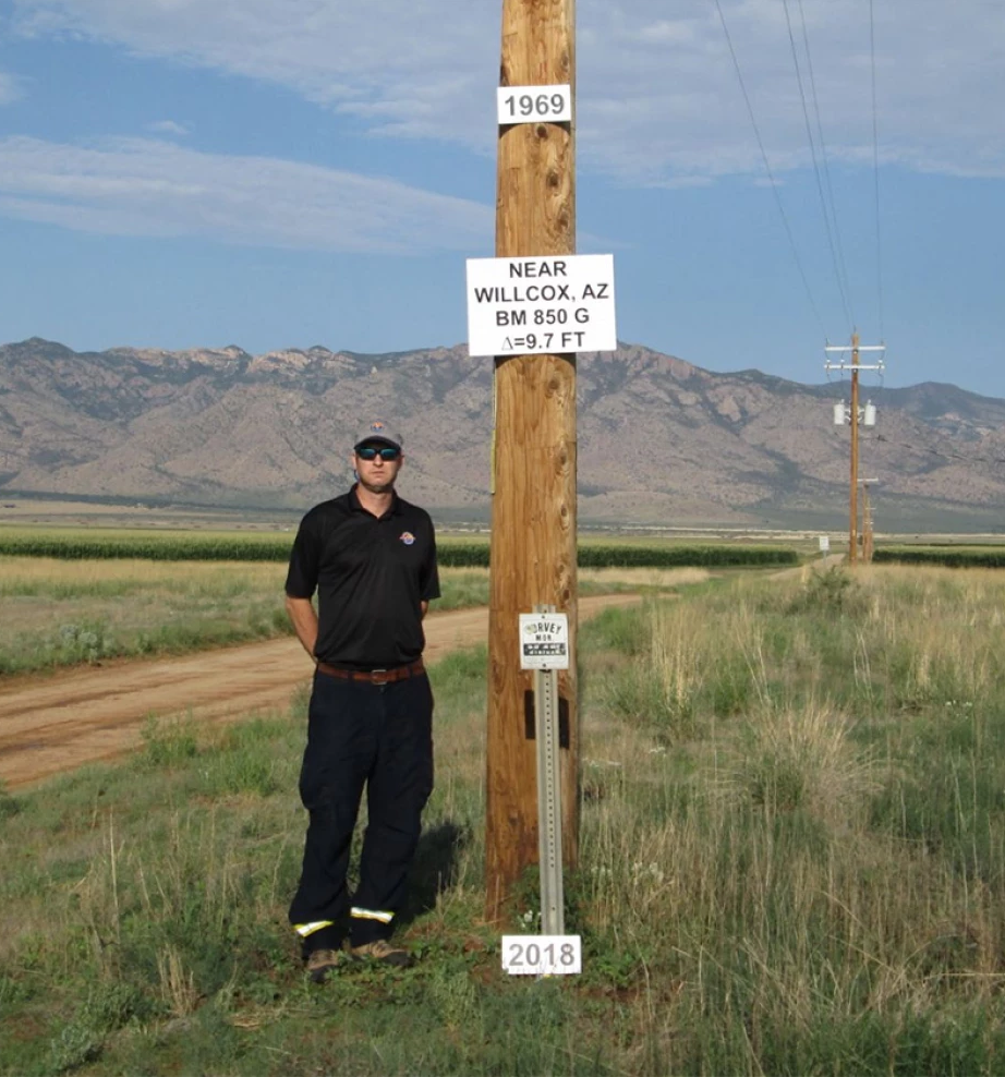
Benchmark BM 850 G near Willcox, Arizona. The 1969 marker at the top of the pole records the original ground surface. By 2018, the land had sunk 9.7 feet — driven by decades of agricultural groundwater pumping that exceeds the aquifer's natural recharge rate. The Willcox Basin has recorded the highest annual subsidence rates in Arizona. Source: Brian Conway / Arizona Department of Water Resources. For educational purposes.
The 1980 Groundwater Management Act - The Promise of “Safe-Yield”
You cannot understand Arizona's current groundwater crisis without understanding the political crisis that produced the law meant to prevent it.
By the late 1970s, Arizona was mining groundwater at a rate that alarmed federal water planners. The state was depleting its aquifers by millions of acre-feet per year with no regulatory framework to slow the drain. The federal government, then in the final stages of funding the Central Arizona Project, issued a direct ultimatum: the Secretary of the Interior threatened to withhold CAP funding unless Arizona enacted comprehensive groundwater reform. The message was blunt — the federal government would not spend billions of dollars delivering Colorado River water to a state that was simultaneously destroying the aquifer system the river was meant to supplement.
The result was the 1980 Groundwater Management Act (GMA), which remains the legal foundation of Arizona groundwater regulation today. The GMA created the Arizona Department of Water Resources (ADWR) and established Active Management Areas — AMAs — over the state's most heavily populated and farmed regions: Phoenix, Tucson, Prescott, and Pinal. Inside an AMA, the GMA imposed strict regulations. It quantified existing groundwater rights, mandated conservation targets for agricultural and municipal users, and required flow meters on all large-capacity wells.
For the Phoenix, Tucson, and Prescott AMAs, the law established a statutory goal of "safe-yield" to be achieved by the year 2025. Safe-yield is the hydrological equivalent of a balanced budget: the volume of groundwater withdrawn each year must not exceed the volume of water naturally and artificially recharged into the aquifer. The goal was ambitious and the deadline was real.
It is now 2025. Safe-yield has not been achieved in any of the major AMAs. In the Phoenix AMA, the gap between withdrawals and recharge is widening, not closing. The failure is not a failure of measurement. It is a failure of statutory design — a product of the compromises and legal fictions built into the GMA from the beginning, and compounded by four decades of growth that outpaced every assumption the law's drafters made.
The Assured Water Supply Program and the CAGRD Loophole
The cornerstone of the GMA's protection for urban growth is the Assured Water Supply program. Before a developer can subdivide land inside an AMA — defined as creating six or more lots — that developer must prove to ADWR that a legally and physically available water supply exists, guaranteed to last 100 years. The 100-year requirement was designed to force developers to confront the long-term hydrological consequences of their projects before the first shovel hit the ground.
In practice, the program’s structure allows a certified water supply to exist on paper in a location where the physical water will never arrive.
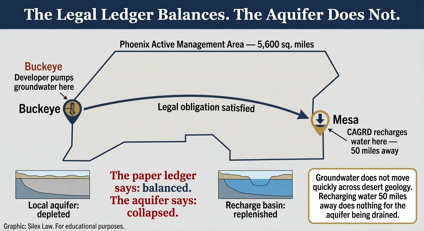
The Central Arizona Groundwater Replenishment District certifies water supplies for subdivisions built outside Active Management Areas — but replenishes that water inside AMAs miles away. The legal obligation and the physical aquifer are in different places. Source: Arizona Department of Water Resources; ADWR Phoenix AMA Groundwater Model (2023). Graphic: Silex Law. For educational purposes.
In 1993, facing sustained pressure from developers who argued that strict physical water requirements were strangling growth, the Arizona Legislature created the Central Arizona Groundwater Replenishment District — the CAGRD. The CAGRD fundamentally rewrote the math of the Assured Water Supply program. Under the CAGRD model, a developer does not need 100 years of wet water physically beneath the subdivision. Instead, the developer can drill a well, pump the local groundwater to serve new homes, and enroll the subdivision in the CAGRD. The CAGRD then assumes a legal obligation to purchase surface water — usually from the Colorado River — and recharge it into the aquifer somewhere else within the same AMA to offset what the subdivision pumped.
The flaw is geographic and it is foundational. An Active Management Area like Phoenix covers more than 5,600 square miles. A developer can build a subdivision on the far western edge of the AMA — in Buckeye, for instance — pump fossil groundwater from beneath that community, and satisfy the legal replenishment obligation by depositing Colorado River water into a recharge basin fifty miles away in the East Valley. The paper ledger balances. The aquifer beneath Buckeye does not recover. Groundwater does not move quickly across dozens of miles of desert geology. Recharging water in one part of a massive basin does nothing to replace the water being physically drained from another part.
The CAGRD treated the aquifer like a perfectly mixed bathtub. The aquifer is not a bathtub. It is a mosaic of distinct sub-basins, each with its own geology, recharge rate, and depletion trajectory. The legal system that was supposed to protect it was designed around an accounting fiction.
The “Paper Water” Economy — Long-Term Storage Credits
The spatial disconnect embedded in the CAGRD is compounded by a second legal mechanism: Long-Term Storage Credits, or LTSCs.
For much of the 1990s and early 2000s, Arizona received more Colorado River water than its cities and farms could immediately use. The state capitalized on this surplus by creating the Arizona Water Banking Authority (AWBA) and incentivizing municipalities, water utilities, and private entities to take that excess surface water and physically sink it into the desert. Entities that delivered surface water to underground storage facilities — or delivered it to farms for use in lieu of groundwater the farmers would otherwise pump — received Long-Term Storage Credits in return. Each credit represented one acre-foot of water notionally stored or saved underground. Credits were legal property. They could be held indefinitely, traded on the open market, and used to satisfy Assured Water Supply requirements.
Over the decades of Colorado River surplus, the system generated millions of these credits. The credits accumulated on paper while the river ran full and the storage facilities stayed busy.
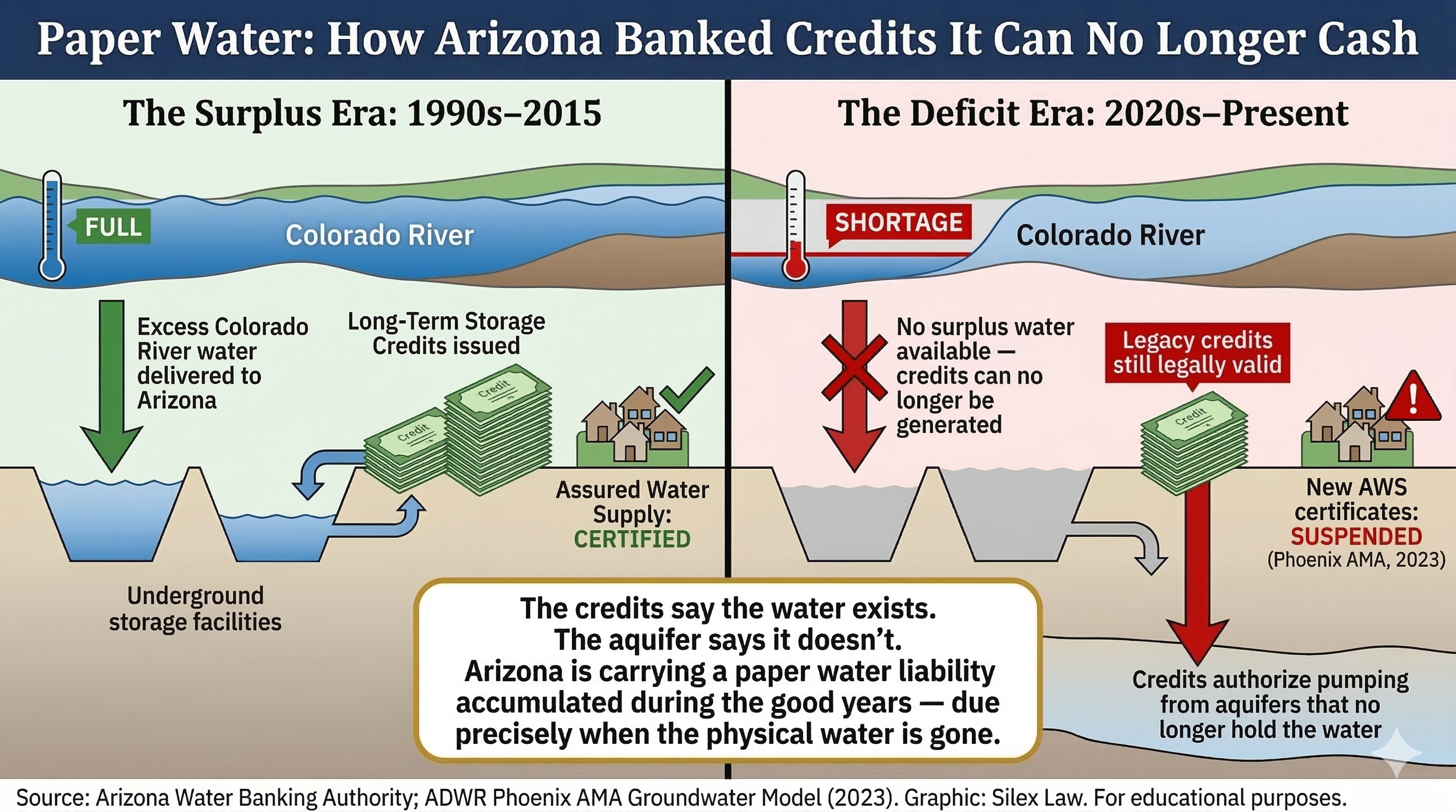
During the surplus era, Arizona banked Long-Term Storage Credits by recharging excess Colorado River water into underground storage facilities. In the deficit era, no surplus water is available to generate new credits — but legacy credits remain legally valid and continue to authorize pumping from aquifers that no longer hold the water. New Assured Water Supply certificates in the Phoenix AMA were suspended in 2023. Source: Arizona Water Banking Authority; ADWR Phoenix AMA Groundwater Model (2023). Graphic: Silex Law. For educational purposes.
The fatal flaw of the LTSC system mirrors the flaw in the CAGRD: credits are completely decoupled from geography and from present-day physical conditions. A city that banked 50,000 acre-feet of water into an East Valley recharge basin in 1998 holds 50,000 credits today. In 2026, a developer can purchase those credits and use them to legally justify pumping 50,000 acre-feet of groundwater from a depleted sub-basin on the other side of the AMA. The law treats the paper credit and the physical groundwater as interchangeable. They are not interchangeable. The credit exists on a ledger. The groundwater it is supposed to represent may no longer physically exist in the location where it is being pumped.
As the Colorado River has shrunk, Arizona's ability to generate new credits has collapsed. There is no surplus river water to bank. But the millions of legacy credits already issued remain legally valid — and they represent legal authorization to pump groundwater from aquifers that the state's own models show are already in deficit. Arizona is carrying a paper water liability it accumulated during the good years, and it is now coming due at precisely the moment when the physical water it represents is gone.
The Unregulated 80% — Groundwater Outside the AMAs
The Active Management Areas govern Arizona's major urban centers. They cover roughly 20% of the state's land area. The remaining 80% of Arizona — the rural counties, the agricultural valleys, the communities that built their lives around domestic wells drawing from shallow aquifers — operates almost entirely outside the GMA's reach.
Outside an AMA, groundwater is governed by the common law doctrine of Reasonable Use. Despite its name, Reasonable Use in Arizona functions in practice as the rule of capture. A landowner may pump as much groundwater as they wish, from as deep as they can drill, for any beneficial use on the overlying land, with no obligation to meter the wells or report the volume to ADWR. The state collects almost no data on how much water is being extracted from most of its rural aquifers.
For decades, this regulatory vacuum was tolerated because rural populations were small and agricultural pumping was relatively stable. That has changed. Attracted by Arizona's cheap land and its absence of groundwater regulation, large-scale corporate agricultural operations have migrated into rural Arizona from states with stricter rules. Foreign-owned industrial dairies, Middle Eastern alfalfa conglomerates growing water-intensive crops for export, and massive nut-tree orchards have purchased vast tracts of land in La Paz, Mohave, Cochise, and other rural counties. These operations sink wells 1,000 to 2,000 feet deep and pump at volumes that dwarf anything the domestic well users nearby can match.
Because groundwater is a shared resource, the massive cones of depression created by industrial-scale pumping quickly intercept the shallow domestic wells relied upon by nearby residents. When a 300-foot domestic well fails because an industrial neighbor has drawn the water table down past its reach, the legal result in rural Arizona is stark and lawful: the domestic well owner has no remedy. The corporate operation has committed no legal wrong. Under Arizona's Reasonable Use doctrine outside the AMAs, the party with the deepest well and the deepest pockets legally appropriates the aquifer. The state watches it happen.
Communities in rapidly depleting rural basins — Willcox, Kingman, the Harcuvar Valley — have watched their domestic wells go dry and their property values collapse while their county governments lack the legal authority to intervene.
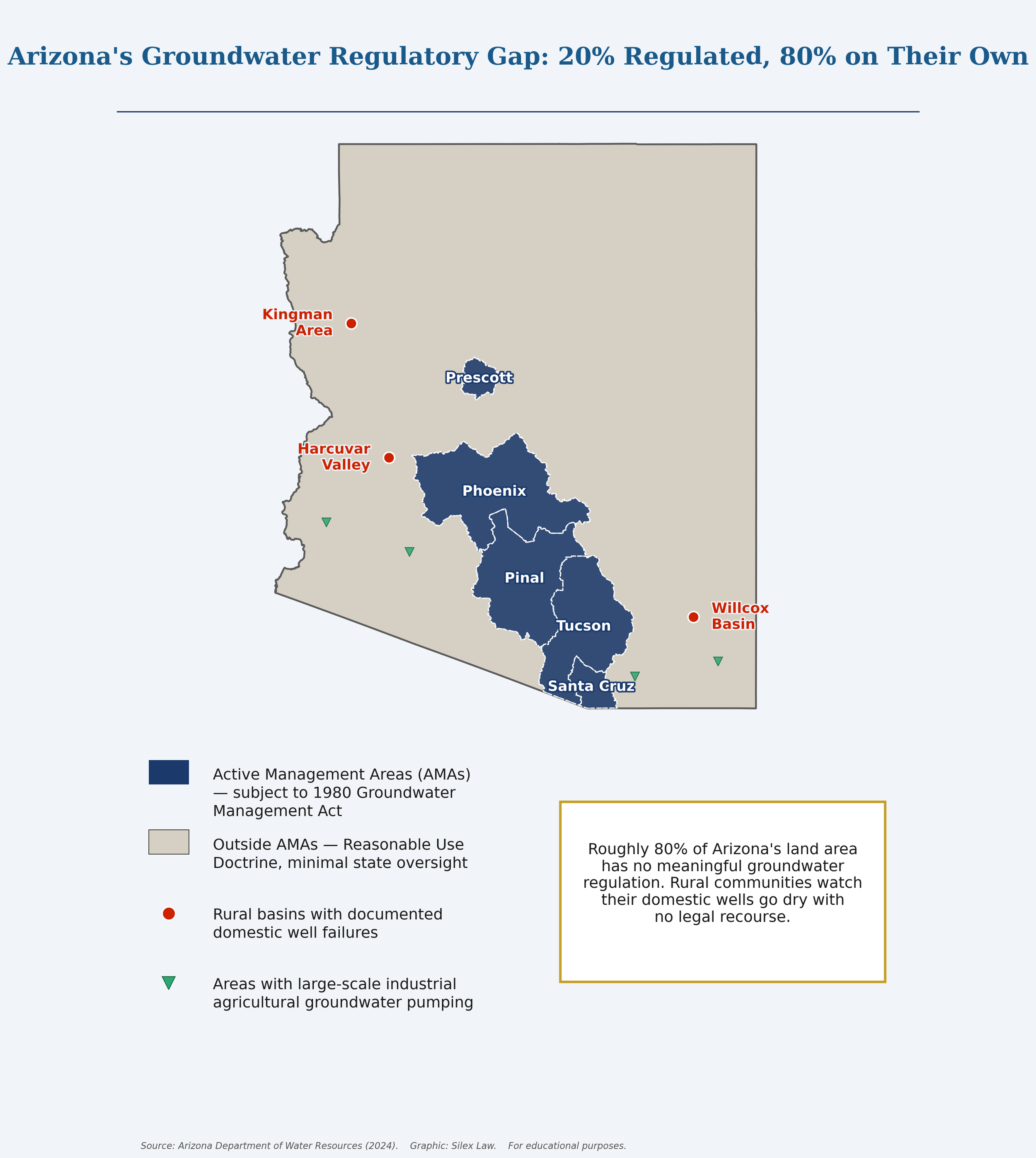
Arizona's five Active Management Areas — Phoenix, Tucson, Prescott, Pinal, and Santa Cruz — cover roughly 20% of the state's land area and are subject to the 1980 Groundwater Management Act. The remaining 80% operates under the Reasonable Use Doctrine, with minimal state oversight. Red markers indicate rural basins with documented domestic well failures. Source: Arizona Department of Water Resources (2024). Graphic: Silex Law. For educational purposes.
The RMA Debate — Local Governance or Corporate Entrenchment
The devastation of rural aquifers has generated intense political pressure to extend some form of regulatory protection outside the AMA boundaries. Residents in depleting basins have petitioned the state for intervention, and policymakers have debated creating Rural Management Areas — RMAs — or Local Groundwater Stewardship Areas as a middle path between the strict AMA framework and the complete absence of regulation that currently governs most of the state.
An RMA would give local communities tools they currently lack: the authority to meter wells, require conservation measures, and potentially restrict new large-scale agricultural expansions. Unlike an AMA, an RMA would not impose the 100-year Assured Water Supply requirements that govern Phoenix and Tucson. The concept is designed for communities that need basic governance, not the full regulatory apparatus built for a major metropolitan area.
These proposals have met fierce and well-funded resistance from industrial agricultural interests. The core dispute centers on grandfathering. Corporate farming operations that are currently pumping large volumes of groundwater without restriction argue that any new regulatory framework must protect their established historical pumping rates. If grandfathering locks in current extraction volumes as permanent entitlements, the RMA framework would formalize the status quo — permitting corporate operations to continue depleting aquifers at industrial rates while preventing new entrants, and leaving local communities with the form of governance but not the substance.
The political paralysis has a physical cost. Every month the legislature fails to act on RMA legislation is another month of unregulated pumping across rural Arizona. Industrial operations understand that historical pumping rates are the likely baseline for any future regulatory scheme. The rational response is to pump aggressively now, before regulation arrives, in order to establish the largest possible historical baseline to grandfather. By the time communities gain the legal authority to manage their own basins, the water those laws were designed to protect may already be gone.
Tribal Reserved Water Rights — The Senior Claims That Cannot Be Forfeited
Under the doctrine established by the United States Supreme Court in Winters v. United States (1908), federally recognized tribal nations whose reservations were carved from lands within or adjacent to water-bearing basins hold reserved water rights with priority dates tracing to the founding of each reservation. These rights were not granted by state law and cannot be taken away by it. They are senior to virtually every state-issued water right in Arizona, including rights that have been exercised for more than a century. Crucially, tribal reserved water rights cannot be forfeited by non-use. A tribe that has not exercised its water right for 100 years still holds it at full priority.
For much of the twentieth century, Arizona water planners treated tribal reservations as blanks on the map — sources of water demand not yet legally quantified and therefore not yet threatening to the state's allocation system. That approach is no longer legally or hydrologically sustainable.
Several of Arizona's tribal nations have successfully litigated or negotiated the quantification of their reserved rights and now hold some of the most consequential water positions in the basin. The Gila River Indian Community secured what remains the largest tribal water settlement in United States history, formalizing its rights to both Colorado River water and reclaimed water under a 2004 settlement. The Community has strategically left significant portions of its Colorado River allocation in Lake Mead under Intentionally Created Surplus and drought contingency agreements, receiving federal compensation in exchange — a financial and legal maneuver that reflects sophisticated water governance, not the passive resource holder the state once assumed.
The Colorado River Indian Tribes occupy an equally pivotal position. The CRIT Water Resilience Act, signed in December 2022, authorized a pilot program allowing CRIT to lease a portion of its senior Colorado River water rights to off-reservation users — including municipalities and water utilities facing supply shortfalls. The Act represents a structural shift: tribal water rights, long treated by state planners as a cost or a complication, are now a potential resource that downstream users will pay to access. The political and legal implications of tribal nations becoming primary suppliers to suburban Arizona are significant and largely unexamined in public policy debates.
Not all of Arizona's major tribal water rights have been quantified. The Navajo Nation, which occupies the largest reservation in the United States and whose territory spans portions of Arizona, New Mexico, and Utah, holds massive unquantified claims to both surface water and groundwater across vast areas of northern Arizona. The Hopi Tribe holds similarly unresolved claims. Unlike state-granted groundwater rights, which can be forfeited or subordinated through various legal mechanisms, these federal reserved rights accumulate as a permanent senior obligation against the state's available water supply. As Arizona's Assured Water Supply system faces mounting pressure from localized aquifer collapse and the loss of Colorado River surface water, the unquantified tribal claims represent a legal variable of enormous magnitude — one that state water planning has consistently underweighted.
Arizona's water future will not be determined solely by ADWR, municipal utilities, or suburban developers. It will be shaped in significant part by the sovereign nations that hold the oldest, largest, and most legally protected water rights in the basin.
The Post-2026 Framework and the Groundwater Blind Spot
In January 2026, the Bureau of Reclamation released the Draft Environmental Impact Statement for the Post-2026 Operational Guidelines governing Lake Powell and Lake Mead — the two massive storage reservoirs that form the spine of the Colorado River system. The DEIS evaluates how the river will be managed after the current interim shortage guidelines expire, and it establishes the federal framework within which Arizona will receive — or not receive — its Colorado River allocation for the foreseeable future.
Because the Central Arizona Project holds junior priority status within the Lower Basin, virtually every alternative evaluated in the DEIS imposes the heaviest cuts on Arizona's CAP deliveries. The specific volumes vary by alternative, but the direction is consistent: Arizona receives less Colorado River water under every scenario the federal government is seriously considering.
The DEIS contains a critical analytical failure that has not received adequate attention. The document evaluates the impacts of Colorado River cuts on reservoir operations, hydropower generation, recreation, and downstream flows. It does not analyze what those cuts will do to Arizona's groundwater system.
This omission is not a technical oversight. It reflects a fundamental fragmentation in federal water management: surface water and groundwater are treated as separate regulatory domains even where they are physically interconnected. In Arizona, they are not separate systems. For decades, Groundwater Savings Facilities — operations where surface water is delivered to farms in lieu of groundwater they would otherwise pump — have been one of the state's primary tools for moderating aquifer depletion. Farmers receive surface water, reduce their groundwater pumping, and the aquifer draws down more slowly. The GSF system has operated as an imperfect but real buffer between surface water deliveries and groundwater demand.
Under every Post-2026 alternative that significantly reduces CAP deliveries, there will be insufficient surface water to operate the GSF system at meaningful scale. The consequence is direct and unavoidable: agricultural users who relied on surface water delivered through GSFs will return to pumping groundwater. The volume of that transition — across the Phoenix and Pinal AMAs — represents a massive, unmitigated shift in groundwater demand that the DEIS does not model, does not project, and does not evaluate. Whether the Final EIS corrects this omission remains to be seen. The physical reality of that demand shift does not wait for the federal government to acknowledge it.
The Collision: When the Accounting Runs Out
In June 2023, the physical reality of Arizona's groundwater situation forced the state's hand in a way that no amount of legal accounting could defer.
ADWR published a new groundwater availability model for the Phoenix AMA projecting a shortfall of approximately 4.86 million acre-feet of groundwater over the next 100 years. The model reflected the combined effect of declining Colorado River supplies, the reduced capacity of the CAGRD to acquire replenishment water, and the continued expansion of development relying on groundwater that cannot physically be replaced. Based on that analysis, ADWR announced it would no longer issue new Assured Water Supply certificates for subdivisions relying entirely on unreplenished groundwater in the Phoenix AMA.
The announcement was framed in administrative language. Its meaning was blunt: the state's own data showed that the water the AWS program was certifying as legally available for 100 years did not physically exist. Arizona had been issuing certificates of water security for developments whose water supply existed only on the legal ledger. The 2023 announcement was not a policy correction. It was a mathematical surrender — the moment when the gap between Arizona's water accounting and Arizona's physical hydrology became too large to paper over.
The 1980 Groundwater Management Act bought Arizona four decades of legal cover for explosive growth. The compromises that made it politically viable — the CAGRD's spatial flexibility, the LTSC system's geographic decoupling, the AMAs' exclusion of 80% of the state's land area — are now the mechanisms of the crisis. Arizona is not running out of water in a simple physical sense. It is running out of the legal fictions that allowed it to treat water it did not have as water it did.
What comes next depends on decisions that Arizona's legislature, its water agencies, tribal nations, the federal government, and the courts will make in the next several years — decisions about how to restructure the Assured Water Supply program, how to extend meaningful regulation to rural basins before they are permanently depleted, how to account for the senior tribal rights that state water planning has long underweighted, and how to manage the transition away from Colorado River dependence without simply transferring that dependence underground. None of those decisions have been made. The aquifers are not waiting.
Additional Resources
Arizona State Government
Arizona Department of Water Resources — Groundwater Management. ADWR's primary hub for Active Management Area information, groundwater management plans, well registration data, and the Assured Water Supply program. The starting point for understanding how the 1980 Groundwater Management Act is administered in practice.
Arizona Department of Water Resources, Long-Term Water Augmentation Options for Arizona (2019). ADWR's assessment of the state's principal options for developing new water supplies — including Colorado River augmentation, water recycling and reuse, stormwater harvesting, and desalination. The foundational state-level analysis informing the post-2026 augmentation framework and the WIFA Long-Term Water Augmentation Fund established by the Legislature the same year.
Arizona Department of Water Resources — Gila River and Little Colorado River General Stream Adjudications. ADWR's overview of the ongoing general stream adjudications — the largest water rights proceedings in Arizona history — including background on tribal reserved rights claims, hydrographic survey reports, and procedural history.
Arizona Water Banking Authority — LTSC Map. The AWBA's interactive GIS map showing Long-Term Storage Credits at each storage facility by AMA, with downloadable data. The primary tool for evaluating the gap between credits on the books and physical water available.
Arizona Water Banking Authority — Annual Reports. The AWBA's annual reports document the volume of Long-Term Storage Credits generated, recharge activity by AMA, and the Authority's financial position. Essential for understanding the paper water economy described on this page.
Water Infrastructure Finance Authority of Arizona (WIFA). Arizona's state authority for financing water infrastructure, conservation, reuse, and augmentation projects. WIFA administers the Clean Water and Drinking Water State Revolving Funds, providing low-interest loans and technical assistance to municipalities and water providers statewide. Reestablished as an independent state agency in 2022 with significantly expanded authority.
WIFA — Long-Term Water Augmentation Fund (LTWAF). The $1 billion fund created by the Arizona Legislature in 2022 to finance new water supply development for Arizona — with at least 75% directed toward water importation projects and up to 25% for in-state augmentation. WIFA is currently in active competitive procurement, having received six water importation proposals in 2025. The LTWAF represents the state's most concrete legislative response to the long-term depletion trajectory described on this page.
Federal Resources
U.S. Bureau of Reclamation — Colorado River Basin Water Supply and Demand Study (2012). The foundational federal assessment of long-term supply and demand imbalance in the Colorado River Basin. Directly relevant to the post-2026 shortage framework and Arizona's dependence on CAP deliveries as a substitute supply for AMA groundwater.
U.S. Bureau of Reclamation — Colorado River Basin Ten Tribes Partnership Tribal Water Study (2018). A comprehensive federal study quantifying unmet tribal water needs across the Colorado River Basin. Documents the gap between legally senior tribal entitlements and actual tribal water use — the deferred reckoning that underlies the post-2026 federal framework discussed on this page.
Legislative & Legal Materials
A.R.S. § 45-401 et seq. — Active Management Areas. The statutory framework establishing Arizona's five Active Management Areas, defining the safe-yield management goal, and setting out the regulatory structure for groundwater use within AMAs. The foundational text of the 1980 Groundwater Management Act.
A.R.S. § 45-453 — Groundwater Rights and Uses Outside Active Management Areas. The statute governing groundwater use in the unregulated 80% of Arizona. Codifies the Reasonable Use Doctrine for areas outside AMAs and establishes that groundwater use in those areas is subject only to the requirement that it be put to a reasonable use on overlying land.
A.R.S. § 45-576 et seq. — Assured Water Supply Program. The statutory framework for the Assured Water Supply requirement, including the 100-year supply demonstration, the role of the Central Arizona Groundwater Replenishment District, and the conditions under which ADWR may issue or suspend certificates.
A.R.S. § 45-801 et seq. — Underground Water Storage, Savings and Replenishment. The statutory framework for the Long-Term Storage Credit program, governing how water is recharged, how credits are issued, and how stored water credits may be applied to satisfy water supply requirements.
In re General Adjudication of All Rights to Use Water in the Gila River System and Source (Gila III), 195 Ariz. 411, 989 P.2d 739 (1999). The Arizona Supreme Court held that federal reserved water rights extend to groundwater as well as surface water and are not subject to prior appropriation under Arizona state law. Gila III established that tribal reserved rights represent a category of senior legal entitlement that operates entirely outside the state groundwater regulatory system — including the AMA framework — and that the quantity of a reserved right is determined by the water necessary to fulfill the purpose of the reservation, not by the amount historically put to use.
Academic & Research Resources
Glennon, Robert J. — Water Follies: Groundwater Pumping and the Fate of America’s Fresh Waters (Island Press, 2002). The foundational legal and popular analysis of how groundwater law fails to account for the hydraulic connection between pumping and surface water depletion. Arizona figures throughout, and the Reasonable Use Doctrine and CAGRD model are examined in depth.
Feller, Joseph M. — The Adjudication That Ate Arizona Water Law, 49 Ariz. L. Rev. 403 (2007). A comprehensive scholarly review of the Gila River general stream adjudication's procedural history and legal consequences, including detailed treatment of the tribal reserved rights interlocutory decisions through Gila V. Available through the Arizona Law Review.
Kyl Center for Water Policy — Arizona Water Facts. Accessible reference data on Arizona water supply, demand, and projected deficits, produced by the Morrison Institute for Public Policy at Arizona State University.
For ongoing legislative, litigation, and regulatory developments related to Arizona groundwater — including AMA management plan updates, CAGRD statutory reform, Rural Management Area legislation, and post-2026 federal shortage framework negotiations — see the Water Crisis Watch, Water Law Decisions, and Water Legislation Watch blogs.